About GPS PAIS VASCO
Explanation of the requested permissions when installing the app: - Access to your location: You need to use the GPS of your device. - Access to internal storage: It is needed when exporting points on the route. Useful...
Explanation of the requested permissions when installing the app:
- Access to your location: You need to use the GPS of your device.
- Access to internal storage: It is needed when exporting points on the route.
Useful and practical GPS with the best features you can find:
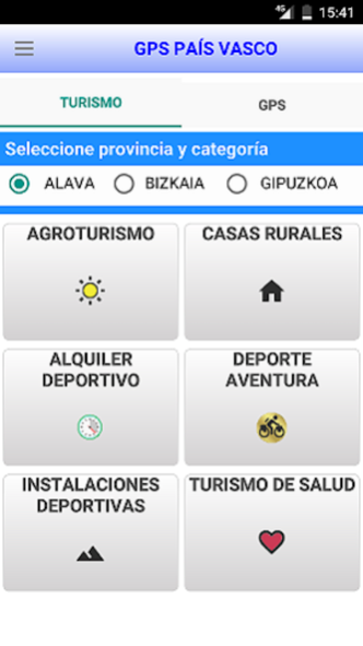
TO MAKE TOURISM FOR THE BASQUE COUNTRY
=====================================================================
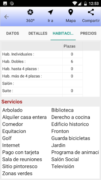
Detailed information on the sites that offer Agrotourism, Rural houses, Sports rental, Adventure sports, Sports facilities and health tourism, with detailed information on the services they offer, email, telephone, prices, number of rooms available, etc.
TO RECORD ROUTES:
==================
- ROUTES: If you run, bike or some other sport you can store the route you have made, and then see it on a map. Record the start time, end time, duration, distance, average speed, maximum speed, slope, minutes per Km, maximum and minimum altitude, time at rest and time in motion, etc.
It allows export of the route to GPX, KML and CSV format.
It allows importing Garmin GPS routes.
Import routes from the Wikiloc website in GPX, KML format.
It allows to adjust the route to the road (avoiding the typical zigzags of the gps)
Color the route indicating which sections you have gone faster or slower.
It shows graphs of altitude and speed of the route.
Record the route in the background.
- STATISTICS: By day, week and month, informing of the kilometers traveled, time, rhythm and calories.
- TIMES: After making several routes, it informs you of the time you have taken to make 500 m, 1000 m, 1500 m. etc. in each of them and shows it in a graph.
UTILITIES RELATED TO GPS
====================================================================
- NAVIGATION BY VOICE (select the best route by car, on foot or by public transport)
- CALCULATES ROUTE BETWEEN TWO POINTS and shows indications in text.
- ELEVATION: Shows the elevation of the terrain along a route.
- NAVIGATION PANEL: Shows latitude, longitude, speed, distance, acceleration, heading, altitude and air pressure.
- SATELLITES: Reports the number of satellites used by the GPS sensor (indicating the signal strength, azimuth, elevation and country of origin of the satellite)
It allows to see in a graph how the power of the signal of each satellite varies with time.
- POINTS OF INTEREST: It allows you to store all the points of interest you need (coordinates, description, altitude, type of marker, etc.).
- ALTIMETER: Obtain the altitude in 3 ways: by consulting Google Maps, according to the altitude data of the GPS and measuring the variation of the atmospheric pressure.
- COMPASS: It informs of the course and the magnetic field.
- SOLAR PARAMETERS: Shows the time of sunrise, noon, minutes of light, zenith, azimuth, elevation and solar declination for each minute of the day with perpetual calendar.
- TRAFFIC: View the traffic information of your city in real time.
- METRO: Shows the map of the subway on the map.
- OFFLINE MAPS: Download offline maps to your mobile.
- GEOGRAPHICAL CALCULATOR. Converts coordinates in degrees, minutes and seconds to degrees / UTM and vice versa.
- SENSORS: Shows all the sensors that the device has and the values that each of them captures.
- EXPORTS routes and points of interest
- IMPORT ROUTES from Wikiloc / Garmin GPS.
- INFORMS THE STATE OF GPS. Indicates coordinates in Degrees, minutes, seconds and UTM, bearing, precision, first fix, UTM zone, central meridian of the area, GPS time, GMT area.
- UPDATE AGPS DATA of the device.
- MEASURE LENGTHS / AREAS by drawing the route on the map.
- GET THE COORDINATES by clicking on the map.
In most modules there are help panels that describe their characteristics in detail.
For people with reduced vision, it includes the option to read aloud the parameters of the screens.
If you like the app, please comment and rate, as this will help me improve it.